Pulse of Earth
Earth is never silent. Every second, plates collide, rock fractures, ground trembles - USGS real-time seismic data transforms into spreading ripples and scars on a 3D globe. Greater magnitude means fiercer ripples and deeper colors. What you see is not a blue planet, but a living creature breathing.
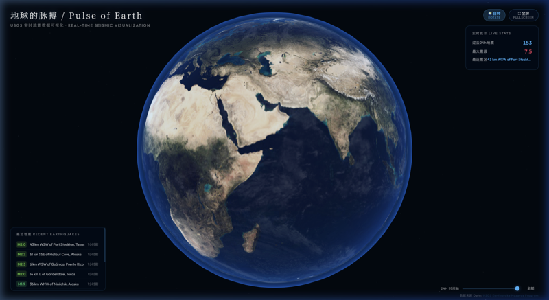
About This Work
The ground beneath our feet is never calm. Pulse of Earth projects USGS (United States Geological Survey) global real-time earthquake data onto a 3D digital globe. Each seismic event generates spreading ripple rings on the sphere's surface - magnitude determines size and duration, from green micro-waves of minor quakes to magenta pulses of major tremors. After ripples dissipate, persistent glowing scars remain at epicenters, accumulating over time until the Earth's surface is gradually covered with these marks - tattoos left by tectonic movement. The stats panel shows live 24-hour earthquake counts, maximum magnitude, and latest affected region. A timeline slider replays the Earth's heartbeat throughout the day. A deep-space starfield slowly rotates in the background, while Fresnel atmospheric glow gives Earth a blue-tinged breath. This is not a static map - it is a real-time portrait of a trembling, living planet.
Features
- USGS real-time earthquake data (auto-refresh every 60s)
- 3D digital globe + procedural continent textures
- Magnitude-to-ripple size/color mapping (M1 green → M7+ magenta)
- Earthquake scar accumulation system (persistent glow points)
- Live stats panel (count/max magnitude/latest region)
- 24-hour timeline replay
- Fresnel atmospheric glow + deep-space starfield
- Mouse hover earthquake details
How to Use
- Real-time earthquake data loads automatically on page load
- Drag to rotate 3D globe view
- Scroll to zoom in/out
- Hover earthquake points for details (magnitude/location/time/depth)
- Drag timeline slider to filter earthquakes by time
- Click rotate button to toggle auto-rotation
- Click fullscreen for immersive mode